Castle Rock is the Douglas County seat and one of the fastest-growing communities in Colorado. The downtown historic district along Wilcox Street and Perry Street holds late-1800s and early-1900s commercial and residential buildings dating to the rhyolite-quarrying era (1870s-early 1900s) when Castle Rock supplied the distinctive volcanic stone for Denver landmarks. The bulk of modern Castle Rock residential dates from 1995 through 2015 across master-planned subdivisions: The Meadows, Founders Village, Crystal Valley, Castle Oaks, Plum Creek, Sapphire Pointe. Lateral material splits sharply: downtown historic = clay tile and first-generation cast iron; master-planned = uniformly schedule-40 PVC. About 25 minutes on camera figures out which catalog applies.
Castle Rock covers roughly 35 square miles in north-central Douglas County. The 2020 census recorded 73,158 residents (per U.S. Census Bureau Castle Rock QuickFacts), with continued rapid growth since. The American Community Survey reports the median Castle Rock housing unit was built in 2003, making it one of the newest median-build communities in the Front Range. The defect catalog therefore differs sharply from older Front Range cities: very little cast iron and clay tile outside the downtown historic core, no significant Orangeburg, and a dominant single failure mode of PVC belly formation from bentonite-driven differential heaving.
Downtown Castle Rock historic core is the original Town of Castle Rock plat along Wilcox Street, Perry Street, and the surrounding blocks. The town was founded 1874 and grew rapidly through the 1880s as a rhyolite-quarrying hub, supplying the distinctive volcanic stone used in Denver landmarks including the Equitable Building, the Brown Palace Hotel, the Trinity Methodist Church, and the Castle Rock Quarry itself. The historic district holds late-1800s and early-1900s commercial and residential buildings on original vitrified clay tile and first-generation cast iron laterals. The Town of Castle Rock Historic Preservation Board maintains records of the original utility installations.
The Meadows is the largest master-planned community in Castle Rock, developed by Castle Rock Development Company starting in 1986 and built out through the 2010s. The neighborhoods inside The Meadows (Maher Ranch, Castlewood, Plum Creek Hills, Bristol Park, Castle View Estates, the Village at Castle Rock) are uniformly schedule-40 PVC laterals. The 1986-1995 Maher Ranch and Plum Creek Hills sections are the oldest stock inside The Meadows.
Founders Village is the Town of Castle Rock's eastern master-planned residential corridor, built 1995 through 2010. The development includes the Castlewood Ranch and Sapphire Pointe sections. PVC laterals throughout.
Crystal Valley is the southwestern Castle Rock master-planned development, built 2005 through 2015 along Crystal Valley Parkway. The site sits adjacent to the Pikes Peak Granite outcrop along the southwest county boundary, so a small fraction of Crystal Valley parcels see the decomposed-granite drainage and frost-jacking patterns more familiar from Roxborough. PVC laterals throughout but with the granitic-soil edge complication on the western parcels.
Castle Oaks Estates and Plum Creek Fairway Estates are smaller master-planned subdivisions south of the historic downtown. Built 1995 through 2010. Castle Oaks Estates is the higher-end golf-course community around the Plum Creek Golf Club. PVC throughout.
Castle Rock industrial and commercial corridor along I-25 and the Outlets at Castle Rock area hosts limited residential but significant commercial property with sanitary laterals serving large-footprint buildings. Light commercial inspection follows the same workflow as residential but with longer camera runs to the larger building footprints.
Soil across Castle Rock sits at the southern edge of the bentonite-rich Pierre Shale exposure that defines the Front Range expansive-soil problem. The Castle Rock town footprint is slightly further from the worst bentonite content than Denver County or Lakewood, but still inside the expansive-soil envelope (per Colorado Geological Survey). The Pikes Peak Granite outcrop along the southwest town boundary provides the non-expansive exception. Elevation runs roughly 6,200 feet at the town center, slightly higher than Denver's 5,280-foot baseline, which adds slightly more aggressive freeze-thaw cycling (95-plus cycles per year per Colorado Climate Center).
1. Bentonite-driven PVC belly formation (The Meadows, Founders Village, Crystal Valley, Castle Oaks). The master-planned Castle Rock subdivisions all sit on Pierre Shale at the southern edge of the expansive-soil envelope. PVC laterals do not crack but do dip and rise as the soil column shifts. On camera: visible drop-and-rise where the camera tilts down through a low spot, with standing water in the dip. The 1986-1995 Maher Ranch and Plum Creek Hills sections inside The Meadows show the most accumulated belly damage simply because the laterals have been in the ground longest. Belly repair runs $1,500 to $4,500 for a single section, with multi-belly runs pushing $8,000 to $12,000.
2. Downtown rhyolite-quarry-era backfill settlement. Original utility runs in the downtown Castle Rock historic district sometimes pass through old quarry-edge backfill from the 1870s-1900 rhyolite-quarrying era. The backfill continues to settle differentially over decades and pulls laterals out of alignment. On camera: visible step-offset at one or more joints. Repair on rhyolite-era backfill properties commonly runs $1,500 to $5,000 because excavation through historic quarry-edge fill requires careful adjacent-foundation protection.
3. Historic downtown clay tile joint failure and root intrusion. The 1880s-1910s housing stock in the downtown core uses vitrified clay tile in 2-to-4-foot mortared sections. Mortar joint failure plus root intrusion dominates. The aggressive Castle Rock-area root species are Siberian elm (heavy throughout the historic district), cottonwood along East Plum Creek, Russian olive across the original town platting, and the occasional ponderosa pine root structure (the Pikes Peak Granite outcrop runs through the southwest town boundary). American Society of Civil Engineers identifies root intrusion as a leading cause of sanitary sewer overflow nationally (per ASCE Infrastructure Report Card).
4. Master-planned-community landscape damage during lateral repair. The Meadows, Founders Village, Crystal Valley all have heavy decorative landscape investment over the lateral run: paver patios, irrigation systems, sodded turf, mature ornamental trees. Lateral repair commonly requires significant landscape restoration work in addition to the trenching itself. Trenchless options (pipe bursting, cured-in-place lining) are attractive in Castle Rock because the avoided landscape restoration cost frequently exceeds the trenchless premium. Trenchless lining runs $1,500 to $4,000 per affected section depending on length.
5. Crystal Valley decomposed-granite frost-jacking on the western parcels. The Pikes Peak Granite outcrop along the southwest Castle Rock boundary is non-expansive but the granular weathered surface drains poorly during the freeze-thaw cycle. Crystal Valley parcels on the western edge of the development sit on the transition zone and can show frost-jacking patterns on top of the standard bentonite-belly pattern. The 95-plus annual freeze-thaw cycles at Castle Rock's 6,200-foot elevation accelerate the frost-jacking relative to lower-elevation cities.
6. Earliest PVC joint cement failures (1986-1992 Maher Ranch). The earliest PVC lateral installations inside The Meadows used solvent-cement joint cementing methods that have shown occasional failure on the 30-40 year mark. The Uni-Bell PVC Pipe Association (per Uni-Bell PVC Pipe Association) documents the 1980s solvent-cement transition as a known historical pattern. On camera: visible joint gaps with surrounding soil intrusion. Repair is sectional replacement, running $4,000 to $15,000 per joint section.
One additional Castle Rock variable: Castle Rock Water is the unified town utility, which simplifies permit coordination relative to the special-district environment further north. The Castle Rock Water permit windows and connection fees are consistent across the entire town regardless of subdivision. The Town of Castle Rock Historic Preservation Board has additional review requirements for any exterior work on downtown historic district properties, which can extend the repair timeline on historic core projects.
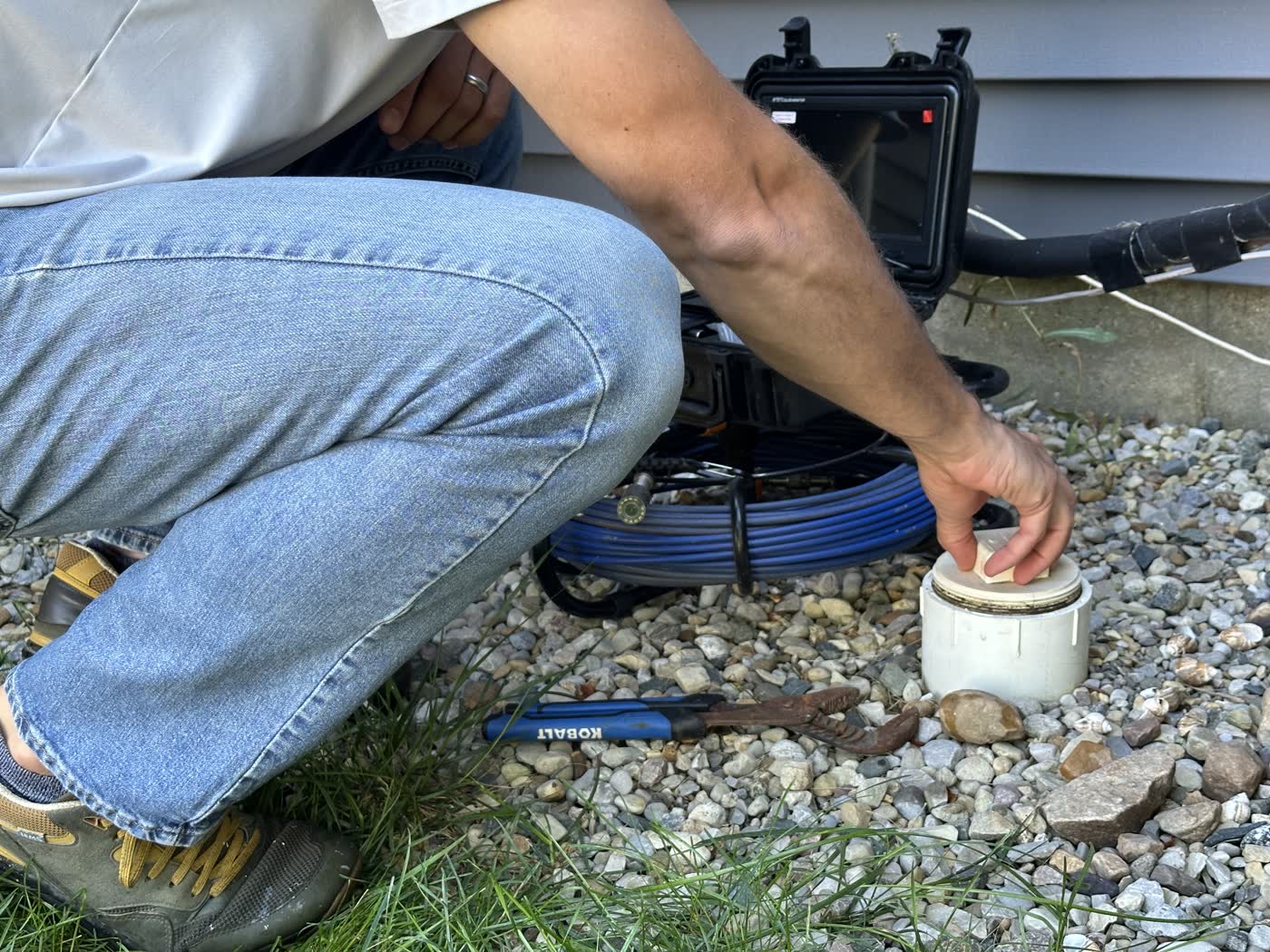
Castle Rock inspections run on the same platform every Sewer Scope metro uses. Booking by phone at (720) 239-2322 or online. Same-week appointment standard, with Mon-Fri 7a-7p MT · Sat 8a-4p window. The technician arrives in the agreed window, locates the cleanout, runs the camera from access to the Castle Rock Water city tap with footage marked, and packs out. The report follows in roughly 24 hours, distributed to buyer, agent, plumber, and lender as requested.
Castle Rock-specific notes: master-planned subdivision homes (The Meadows, Founders Village, Crystal Valley, Castle Oaks) have standard exterior cleanouts and run quickly. Downtown historic district properties may have no exterior cleanout and require access through a basement toilet or a removed cleanout cap on the interior stack. We confirm access during booking. Trenchless repair recommendations are common for Castle Rock master-planned properties because of the landscape restoration math.
Castle Rock has two completely different defect catalogs. Downtown along Wilcox and Perry Streets holds late-1800s and early-1900s buildings on original clay tile and first-generation cast iron, dating to the 1870s rhyolite-quarrying era. The Meadows, Founders Village, Crystal Valley, Castle Oaks, and Plum Creek master-planned subdivisions are all post-1995 schedule-40 PVC throughout. A scope on a downtown historic property follows the high-defect-rate clay tile catalog; a scope on a Meadows or Crystal Valley home follows the bentonite-driven PVC belly catalog.
Source: Town of Castle RockCastle Rock served as a rhyolite-quarrying hub from the 1870s through the early 1900s, supplying volcanic stone for Denver landmarks like the Equitable Building, the Brown Palace Hotel, and Trinity Methodist Church. Some original utility runs in the downtown historic district pass through old quarry-edge backfill, which settles differentially over decades and pulls laterals out of alignment. Repair on rhyolite-era backfill properties commonly runs $1,500 to $5,000 because excavation through historic quarry-edge fill requires careful adjacent-foundation protection.
Source: Castle Rock historic preservationCastle Rock Water is the unified utility for the Town of Castle Rock, covering both drinking water supply and sanitary collection. Castle Rock Water operates independently of the Centennial Water and Sanitation District that serves Highlands Ranch and the Castle Pines Metropolitan District that serves the City of Castle Pines. Castle Rock Water permit windows and connection fees are unified across the entire town, simplifying repair-permit coordination.
Source: Castle Rock WaterThe Meadows is the largest master-planned community in Castle Rock, developed by Castle Rock Development Company starting 1986 and built out through the 2010s. The neighborhoods inside (Maher Ranch, Castlewood, Plum Creek Hills, Bristol Park, Castle View Estates) are uniformly schedule-40 PVC. Defect pattern is dominated by bentonite-driven PVC belly formation, with the older 1986-1995 Maher Ranch and Plum Creek Hills sections showing the most accumulated belly damage.
Source: The Meadows communityFounders Village is the eastern master-planned corridor, built 1995 through 2010, including Castlewood Ranch and Sapphire Pointe. Crystal Valley is the southwestern master-planned development along Crystal Valley Parkway, built 2005 through 2015. Both follow the standard Douglas County master-planned PVC pattern with bentonite-driven belly formation as the dominant defect mode. Crystal Valley sits adjacent to Pikes Peak Granite outcrop, so a small fraction of western parcels also see decomposed-granite drainage and frost-jacking patterns.
Source: Town of Castle RockYes. Colorado Revised Statutes 38-35.7-102 and the SPD19 disclosure form require the seller to disclose the source of water and sewer service, any known defects, and any history of backups or repairs. DMAR treats pre-listing scope as best practice on any Castle Rock listing, essentially mandatory on downtown historic district pre-1940 listings because of the rhyolite-era backfill and clay tile prevalence. For master-planned listings, scope is recommended for baseline documentation of the bentonite-driven belly profile.
Source: Denver Metro Association of REALTORSCastle Rock is one of the highest-velocity new-construction-resale markets in the Front Range for Denver Metro Association of REALTORS (DMAR) members listing through REcolorado MLS (per DMAR and REcolorado). The scope conversation here splits by submarket: downtown historic district pre-1940 listings are essentially mandatory because of the rhyolite-backfill and clay tile risk; The Meadows, Founders Village, and Crystal Valley master-planned listings are baseline-documentation candidates because of the bentonite-PVC belly pattern that is invisible without a camera. Colorado Revised Statutes 38-35.7-102 and the SPD19 disclosure form require sewer-system disclosure. Same professional report and high quality video. Same 24-hour turnaround. Clean handoff.
Castle Rock is the county seat. Highlands Ranch, Parker, Lone Tree, Castle Pines also Douglas.
4 villages, Centennial Water + Sanitation, no muni govt. 1981-2010 PVC.
Aurora west, Centennial, Englewood, Cherry Hills. Mostly 1960s-1990s suburban.
Capitol Hill, Park Hill, Berkeley, Wash Park, Stapleton. Full century build spread.
Arapahoe + Adams split. Original Aurora 1920s clay, Tower 1990s+ PVC.
Belmar, Green Mountain, Federal Center. 1950s-1980s build dominant.